The Ha Giang Loop is not just a journey; it’s an adventure that combines breathtaking landscapes with a series of terrain challenges that both novice and experienced riders will encounter. Whether you’re cruising through lush green valleys, navigating through steep mountain paths, or facing unpredictable weather conditions, the loop offers a range of difficulty levels that are sure to test your riding skills. Understanding these challenges is crucial for anyone looking to embark on this incredible route. As we dive into the nuances of the Ha Giang Loop’s difficulty, we will explore the various levels, the factors influencing those difficulties, and the skills and fitness required for a successful trip. This guide will give you a comprehensive understanding of what to expect on your adventure.
Overview of the Difficulty Levels on the Ha Giang Loop
The Ha Giang Loop is divided into three main difficulty levels: Easy, Moderate, and Difficult. Each category presents unique challenges, catering to a diverse range of riders. Below is a detailed overview of these difficulty levels, emphasizing the distinctive features of each.
Easy Routes:
Example: Ha Giang City to Tam Son
Distance: Approximately 60 km
Experience Level: Suitable for beginners
Road Condition: Smooth, well-paved roads with gentle curves.
Notable Stops: Scenic spots such as Bac Sum Pass and Quan Ba Heaven Gate, perfect for photography and relaxation.
Moderate Routes:
Example: Yen Minh to Dong Van
Distance: About 100 km
Experience Level: Requires some intermediate riding experience
Road Condition: A mix of well-paved and unpaved sections with steeper inclines that feature sharper curves.
Riding Skills Required: Riders should be competent in handling a motorcycle on varying terrains with confidence.
Difficult Routes:
Example: Meo Vac to Du Gia
Distance: About 90 km
Experience Level: For experienced riders only
Road Condition: Steep ascents, rough unpaved sections, and sharp hairpin bends that challenge the rider’s skills.
Notable Features: Breathtaking views of Ma Pi Leng Pass, requiring significant technical riding ability and confidence.
Understanding these differences will help riders prepare adequately for their journey, ensuring they select routes that match their skill levels and physical capabilities. The table below summarizes these difficulty levels:
Difficulty Level
Example Route
Distance
Experience Needed
Road Condition
Easy
Ha Giang City to Tam Son
60 km
Beginner
Smooth, well-paved
Moderate
Yen Minh to Dong Van
100 km
Intermediate
Mixed conditions, steeper inclines
Difficult
Meo Vac to Du Gia
90 km
Experienced
Rough, steep, technical
.png)
Factors Contributing to the Difficulty of the Ha Giang Loop
Several factors come into play when assessing the overall difficulty of the Ha Giang Loop. Each of these elements presents its own unique challenges, making the journey both thrilling and demanding.
Elevation Changes: The loop features significant elevation gains, often exceeding 2,000 meters (around 6,600 feet). This presents difficulties not only in terms of physical exertion but also with altitude-related symptoms like dizziness or fatigue. Riders may struggle with maintaining balance and control as they ascend and descend steep inclines.
Terrain Quality: The Ha Giang Loop is infamous for its mix of well-paved highways and rough, unpaved paths. Riders often find themselves navigating rocky, gravel-strewn roads, which require a high level of concentration and motorcycle handling skill. Getting comfortable on these surfaces can take some practice, especially during descents where losing traction is a real possibility.
Weather Conditions: Weather in Ha Giang can be unpredictable. The rainy season typically runs from May to October, during which time roads can become slippery due to mud and potential flooding. Rain can lead to landslides, blocking paths and complicating navigation. On the other hand, the dry months present clearer conditions but can bring about high temperatures, adding to the stamina needed for long rides.
Wildlife and Local Traffic: Riders should remain vigilant for wildlife crossing the roads, which is common in rural areas. Furthermore, local traffic can include farm vehicles and people walking along the roads, necessitating constant attention and quick reflexes to avoid accidents.
Physical and Mental Endurance: Long hours of riding can mentally fatigue even the most seasoned riders. A strong physical condition is essential to manage uncomfortable riding positions and fatigue. The combination of physical demands and mental focus significantly raises the loop’s difficulty level.
To navigate these challenges successfully, riders should undertake rigorous preparations that address each of these factors, ensuring that their experience is both safe and enjoyable.
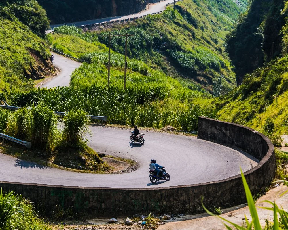
Ha Giang Loop Terrain Challenges
The Ha Giang Loop’s diverse and intricate terrain presents a wide range of challenges for adventurers. Every section of the loop is distinct, and understanding these differences is crucial for successful navigation. Riders should be mentally and physically prepared to face various terrains that demand a strong command of riding skills.
Common Terrain Types Encountered on the Ha Giang Loop
Various terrain types characterize the Ha Giang Loop, each with its own quirks and challenges that riders must adapt to:
Mountainous Roads: The most iconic aspect of the loop includes steep, winding mountain passes, particularly around areas such as Ma Pi Leng Pass. These roads are often narrow and lined with cliffs, requiring advanced riding techniques to handle sharp turns and sudden elevation changes.
Unpaved Sections: Certain parts of the loop feature rugged, gravel-laden roads. These unpaved stretches can be tricky, especially after rain, where loose gravel makes it easy to lose control. Concentration is essential to maintain traction and stability when navigating these areas.
River Crossings: Some routes involve crossing rivers, sometimes via makeshift bridges. While this adds an element of adventure, it also requires caution and experience to cross safely, particularly during peak rainy seasons when river levels may rise.
Flatlands: Unlike the steep ascents, some areas provide flat terrains where riders can recuperate. However, these regions can also hide unexpected potholes or loose rocks, demanding continuous alertness from riders.
Hills and Valleys: Valleys surrounded by hills often create sudden shifts in elevation, requiring riders to frequently adjust their speed and gear. The alternating flatlands and hills maximize both the scenic experience and the challenge for riders.
Each of the terrain types requires different handling skills and a keen sense of awareness, making it imperative for riders to prepare for the unexpected. A well-rounded understanding of these areas can significantly enhance both safety and enjoyment while traversing the Ha Giang Loop.
Specific Challenges Presented by Each Terrain Type
Each type of terrain encountered within the Ha Giang Loop brings specific challenges that can test a rider’s skill and confidence. Understanding these challenges in detail can better prepare individuals for what lies ahead.
Mountainous Roads:
Challenges: Riders must navigate steep inclines and narrow pathways, often alongside sheer drop-offs. This can provoke feelings of vertigo, especially for those unfamiliar with such high altitudes.
Riding Technique: Mastering techniques such as countersteering and throttle control is essential for maintaining stability and control.
Unpaved Sections:
Challenges: Loose gravel and rocky surfaces can result in skidding. Riders require agility and caution as they navigate these unpredictable surfaces to avoid falling.
Riding Technique: Smooth acceleration and braking are critical. Sudden movements can lead to loss of traction.
River Crossings:
Challenges: Water levels can fluctuate, and submerged obstacles are often hidden, presenting risks of losing balance or stalling.
Riding Technique: Riders should assess the depth and current before attempting a crossing. Slow and steady riding helps maintain control.
Flatlands:
Challenges: Riders may underestimate hazards, such as sudden potholes or sharp rocks, which can cause flat tires or mishaps.
Riding Technique: Keeping speed moderate helps with spotting potential obstacles in advance.
Hills and Valleys:
Challenges: Rapid changes in elevation can exhaust riders and confuse route navigation amid winding trails.
Riding Technique: Using lower gears helps with engine control during steep descents while providing better power during ascents.
Having a fully informed perspective of these specific challenges allows riders to strategize and prepare accordingly, ensuring greater safety and overall satisfaction on their journeys through the Ha Giang Loop.
Seasonal Changes and Their Impact on Terrain Challenges
The performance of the Ha Giang Loop can change dramatically with the seasons. Each period brings distinct weather patterns that can influence the difficulty and overall riding experience. Understanding these seasonal impacts is essential for planning the trip.
Rainy Season (May to October):
Terrain Effects: Heavy rains lead to slippery surfaces and can wash away road integrity, making some routes significantly dangerous. Ditches and ravines may become filled with water, complicating navigation.
Rider Preparedness: Riders should equip themselves with proper rain gear and plan routes accordingly. Awareness of weather forecasts can help in avoiding particularly treacherous sections.
Dry Season (November to March):
Terrain Effects: These months generally offer more stable and predictable conditions. Roads tend to be drier, thus improving traction and visibility.
Scenic Attractions: Riders can experience stunning views, especially when the rice paddies turn golden in October, motivating travelers to ride through these picturesque landscapes.
Transitional Months:
Terrain Effects: Months like April and late October can present unexpected transitions where trails may still be muddy due to residual rainfall or experience sudden rain showers.
Rider Adjustments: During these times, maintaining cautious riding speeds is important. Riders should also be ready to navigate through mixed road conditions.
Temperature Variability:
Terrain Effects: Elevation can create varied temperatures throughout the loop, leading to alternative weather challenges as riders ascend or descend steep hills.
Rider Considerations: Layering clothing can effectively combat these temperature fluctuations and ensure that riders remain comfortable throughout their journey.
Recognizing how seasonal changes affect the terrain can empower riders to make informed decisions about timing their trip and preparing adequately for varying conditions on the Ha Giang Loop.
Ha Giang Loop Elevation
The Ha Giang Loop is remarkable not just for its breathtaking beauty but also for its impressive elevation profile, which presents unique challenges for motorbike riders. As you navigate through the loop, you’ll encounter significant changes in elevation, shaping both the journey and riding experience.
Understanding the Elevation Profile of the Ha Giang Loop
The elevation profile of the Ha Giang Loop is characterized by its dramatic inclines and varying altitude levels, ranging from rolling plains to rugged mountain peaks.
Starting Point: The loop begins in Ha Giang City, with an elevation of about 180 meters (590 feet) above sea level.
Peaks at High Altitudes: The highest points can exceed 2,000 meters (6,600 feet), particularly around areas like Ma Pi Leng Pass and Lung Cu. Current elevation levels can lead to enhanced views that showcase the breathtaking mountain ranges but also come with physical challenges, especially for those unaccustomed to high altitudes.
Elevation Drops: Following peaks, the loop features steep descents that provide exhilarating riding experiences but may also necessitate careful control to navigate sharp hairpin turns safely.
Elevation Changes and Rider Experience: Riders may experience difficulty breathing and fatigue due to reduced oxygen levels at high elevations. Adapting to these changes is essential, and planning rest stops every few kilometers can help mitigate these issues.
Understanding the elevation profile allows riders not only to appreciate the geographic marvels of the Ha Giang Loop but also to prepare physically and mentally for the demands placed upon them during their adventure.
How Elevation Affects Difficulty and Terrain
Elevation plays a critical role in determining the overall difficulty and nature of the terrain along the Ha Giang Loop. Each altitude zone introduces unique challenges that every rider must navigate.
Breathing Difficulties:
As riders ascend, the decrease in oxygen availability can create challenges in breathing and fatigue, particularly for those who are not acclimatized.
Symptoms of altitude sickness, while rare, may require awareness and preparation, including hydration and rest to help the body adjust.
Increased Technical Skill Requirement:
High altitude areas present technical riding challenges such as steep climbs and sharp bends, requiring careful throttle and brake management.
Riders must develop the ability to anticipate potential dangers, like decreases in speed on uphill climbs or loss of traction on downhill descents.
Visibility and Weather Changes:
Higher elevations can lead to sudden shifts in weather that impact visibility and road safety, such as fog or rain. This necessitates adjustments in speed and careful navigation skills.
Low-visibility conditions make it harder to gauge road conditions, so riders must remain vigilant and ready to adapt their strategies.
Physical Endurance:
Long stretches of elevation changes can be physically exhausting. Riders must be prepared for extended riding times to cover altitude-related segments of the loop.
A routine of core and stamina-building exercises prior to the trek will enhance performance and help manage fatigue resulting from extensive periods on steep terrains.
Riders should pay close attention to these elevation-related factors when planning their trips, ensuring they build their endurance capabilities to meet the challenges presented throughout the Ha Giang Loop.
Key Elevation Points Along the Ha Giang Loop
Understanding the key elevation points along the Ha Giang Loop enhances both preparation and riding strategy. Here are the major elevation highlights and their associated challenges:
Ma Pi Leng Pass:
Elevation: Approximately 1,200 meters (3,900 feet).
Challenges: This pass is known for its steep climbs and sharp turns. Novice riders may find it intimidating, while seasoned riders appreciate the stunning views it offers.
Bac Sum Pass:
Elevation: Roughly 1,050 meters (3,445 feet).
Challenges: The significant elevation changes demand good riding skills. The breathtaking panoramic scenery is often a reward for the effort.
Dong Van Karst Plateau:
Elevation: Exceeding 1,400 meters (4,593 feet).
Challenges: The plateau features elevation-heavy paths requiring high physical fitness and technical riding skills, especially on the rough terrain.
Lung Cu (Northernmost Point):
Elevation: About 1,500 meters (4,921 feet).
Challenges: As the highest point in Vietnam, it offers impressive vistas but presents the need for careful navigation due to steep walls and narrow paths.
Addressing the specific altitudes of these notable points allows riders to better optimize their physical preparedness and improve their riding skills relevant to different elevations during their Ha Giang Loop adventure.
Ha Giang Loop Travel Skills
Navigating the Ha Giang Loop requires a comprehensive set of travel and riding skills tailored to the unique challenges presented by its terrain and elevation changes. Preparing adequately in these areas can significantly impact the overall experience.
Essential Driving Skills for Navigating the Ha Giang Loop
To ensure a safe and enjoyable ride, various essential driving skills are necessary to cope with the unpredictable and diverse landscape found along the Ha Giang Loop:
Terrain Navigation Skills:
Understanding the different terrain types is crucial. Riders should hone their abilities in maneuvering deeply rooted inclines, narrow trails, and unpredictable road surfaces.
Familiarity with the bike’s handling capabilities is important, as well as mastering techniques such as leaning into turns and maintaining balance on uneven surfaces.
Handling Adverse Weather:
The ability to adapt riding techniques based on current weather conditions is important. For example, in wet conditions, slowing down and maintaining a wider distance from other vehicles can enhance safety.
Riders should also familiarize themselves with emergency braking techniques in slick conditions, as well as techniques to regain control in case of skidding.
Speed Management:
Riding at appropriate speeds is not only a safety precaution but also a means of conserving energy during long rides.
Managing speed effectively on steep descents requires specific techniques, such as incorporating engine braking to minimize wear on brake systems and maintain better control.
Equipment Maintenance Knowledge:
Basic mechanical knowledge can prove invaluable during a journey. Understanding the fundamentals of motorcycle repair, such as fixing a tire or addressing minor mechanical issues, can significantly reduce the risk of being stranded.
Carrying essential tools and a basic repair kit is advisable, allowing quick fixes to be made on the road.
Observation Skills:
Maintaining awareness of surroundings, whether it be the terrain, other vehicles, or wildlife, can prevent potentially dangerous situations.
Riders should periodically check their mirrors and surroundings to remain vigilant about oncoming threats.
Developing these essential driving skills will not only help ensure safety but will also enhance the overall enjoyment of navigating the stunning routes of the Ha Giang Loop.
Navigation Skills: Maps vs. GPS in Ha Giang
When it comes to navigating the Ha Giang Loop, understanding the strengths and limitations of maps versus GPS can greatly enhance overall travel experiences.
Maps:
Traditional paper maps remain valuable, especially in remote areas where signal coverage for GPS may be unreliable. Detailed maps provide insights into terrain types, road conditions, and elevation changes.
Familiarity with reading maps can enhance awareness of potential hazards or points of interest along the journey.
GPS:
GPS applications tend to offer real-time directions and updates on current location, aiding in route planning. They can provide useful data about distances and estimated times.
However, network coverage can be spotty in remote locations, making reliance solely on GPS risky. Without a backup plan, riders may find it difficult to navigate through areas lacking connectivity.
Combining Tools:
The best navigation strategy may involve a combination of both maps and GPS technology. Utilizing a physical map for broader route planning alongside a GPS application for real-time guidance can optimize navigation.
Riders should practice switching between the two tools seamlessly, adapting based on conditions.
Local Knowledge and Resources:
Engaging with local communities or experienced riders can provide invaluable insights into the best routes and any potential dangers.
Developing a network of fellow travelers can further enhance navigation skills, offering the opportunity to exchange tips and share routes.
By understanding the strengths and weaknesses of navigation tools, riders can better prepare for the unexpected twists and turns encountered on their journey through the Ha Giang Loop.
Group Travel vs. Solo Travel Skills on the Ha Giang Loop
Whether opting for group travel or solo trips on the Ha Giang Loop, each approach presents distinct advantages and challenges. Understanding these differences can help travelers choose the right experience for their journey.
Solo Travel:
Pros: Offers independence and the freedom to explore at one’s own pace. Riders may immerse themselves more deeply in local cultures, interacting more freely with locals.
Cons: Requires a higher skill level due to navigating challenging terrains and unpredictable conditions alone. Solo riders must possess confidence and self-reliance in handling technical difficulties.
Group Travel:
Pros: This option provides enhanced safety due to collective support, particularly for novice riders. Riding in a group fosters camaraderie, offering the comfort of shared experiences and guidance from more experienced companions.
Cons: Group dynamics can sometimes affect pacing. More structured itineraries may not allow for spontaneous adventures or individual exploration opportunities.
Skill Requirements for Both:
Regardless of travel type, fundamental skills such as terrain navigation, vehicle control, and adaptive riding strategies remain essential. Riders should possess the mental acuity to handle diverse situations encountered on the road, be it in a group or alone.
Preparation and Planning:
Planning is vital for both travel styles. Solo riders must ensure accurate route mapping, including landmarks or rest stops, while group riders should consider establishing communication methods (such as walkie-talkies) to enhance group coordination.
Weather and terrain assessments should be central to planning, ensuring all riders are adequately prepared for potential challenges.
In conclusion, both travel styles come with their unique sets of skills and requirements, ensuring that every rider can find an approach that resonates with their preferences and abilities while exploring the Ha Giang Loop.
Ha Giang Loop Fitness Requirements
Engaging in the Ha Giang Loop requires not only adequate riding skills but also significant physical fitness. The diverse terrains and elevations demand a solid level of stamina to ensure a safe and enjoyable experience.
Physical Fitness Levels Recommended for Ha Giang Loop Travelers
Preparing physically for the Ha Giang Loop is essential, as riders will face a variety of challenges that require endurance and resilience. Here are fitness levels and training recommendations:
Cardiovascular Fitness:
Good cardiovascular health is vital for enduring long hours of riding, which can be physically taxing. Engaging in activities like running, cycling, or swimming can help boost heart health and endurance.
Riders should aim for 30-50 minutes of cardiovascular exercise at least three times a week in preparation for their journey.
Strength Training:
Focus on core strength, leg muscles, and upper body stability. Core strength is critical for maintaining balance on the bike and managing fatigue during extended rides.
Incorporating resistance training sessions focusing on the legs and back can improve overall strength, vital for managing the physical demands of the loop.
Flexibility and Agility:
Stretching exercises and yoga can enhance flexibility and agility, helping riders adapt to the physical demands of riding over varied terrain.
Practicing balance through exercises that challenge core stability will improve overall riding performance and reduce the risk of injury.
Endurance Activities:
Riders should gradually increase ride lengths on their motorcycles, gradually building up to their intended travel duration on the loop.
Engaging in weekend rides on similar terrains or participating in day-long biking events can help simulate the challenges experienced during the Ha Giang Loop.
Awareness of Health Issues:
Riders with existing health conditions such as cardiovascular issues should consult with health professionals prior to embarking on the loop. A tailored fitness approach may be necessary.
Establishing a routine of monitoring physical health, hydration, and energy levels while riding is also crucial.
By adequately preparing for physical demands, travelers can ensure they fully enjoy the adventurous spirit of the Ha Giang Loop, celebrating the stunning landscapes without overextending or risking their health.
Preparing Physically for the Ha Giang Loop Experience
Preparing physically for the Ha Giang Loop is not just about building muscle and endurance it’s about crafting a comprehensive approach to health and training that aligns with the unique challenges of the journey. Here are strategies to ensure readiness:
Routine Assessments:
Conduct regular evaluations of fitness and health levels. Keeping a journal of training routines and physical responses is helpful for tracking individual progress and gauging improvements over time.
Incorporating rest days is equally vital, allowing for recovery and adaptation to training.
Training in Varied Conditions:
Simulate the challenging conditions of the Ha Giang Loop by practicing in hilly terrains or rough roads that resonate with the actual riding experience.
Participate in multi-day riding expeditions or off-road biking sessions to adapt physically and mentally to prolonged exposure to riding.
Mental Preparation:
Mental resilience is as important as physical fitness. Engaging in mindfulness and visualization techniques can aid in mental fortitude, providing focus during physically and mentally taxing rides.
Setting incremental distance goals can help build confidence and ensure that riders are well-prepared for the journey ahead.
Nutrition and Hydration:
Maintain a balanced diet rich in whole foods, accessed through a calculated meal plan that energizes before long rides and aids recovery post-ride.
Staying hydrated is essential; plan routine breaks for hydration and nutrition during rides to sustain energy levels.
Consultation and Support:
Seek professional advice or fitness coaching to support personalized training plans. Group training programs or fitness workshops can also foster camaraderie and shared experience, enhancing motivation.
Sharing experiences with fellow riders can ensure personalized insights relevant to tackling the challenges of the loop.
Equipping oneself with physical preparedness strategies can significantly enhance the enjoyment and fulfillment of navigating the beautiful yet challenging Ha Giang Loop.
Endurance Challenges Faced During the Ha Giang Loop
The Ha Giang Loop’s challenges are as exhilarating as they are strenuous. Endurance plays a key role in traversing this magnificent route. Below are some of the prominent endurance challenges riders may encounter:
Long-Distance Riding:
Covering distances of up to 350 km in a single day can be exceptionally taxing. Extended periods on the motorcycle can lead to fatigue, affecting focus and riding capabilities.
Scheduled breaks that allow for recovery are essential to maintain energy and clarity while navigating challenging segments.
Elevation-Related Fatigue:
Rapid ascents can lead to feelings of exhaustion due to altitude changes. Riders may experience shortness of breath, especially if they are not acclimatized to higher altitudes.
Ensuring adequate hydration and pacing oneself maintains energy levels and mitigates the feeling of fatigue.
Steady Control on Challenging Terrain:
Riding on rough, unpaved roads requires both mental and physical focus, as well as comprehensive body endurance to manage the shocks and strains involved in this form of riding.
Practicing endurance training that includes mountain biking or off-road riding can better prepare riders for these situations.
Staying Alert:
The diversity of the road, combined with wildlife and local traffic, necessitates a high level of concentration. Maintaining alertness over long distances is a significant challenge.
Adequate rest and strategies for combating fatigue, such as shared riding or alternating riders, can help maintain focus.
External Factors:
Unpredictable weather conditions can compound endurance challenges. Rain can lead to soggy roads, requiring extra effort to maintain control.
Riders should also prepare for changing temperatures throughout the day, requiring a keen adjustment of layers worn during the ride.
Recognizing these endurance challenges allows for well-structured preparations, ensuring riders can embrace the rewarding yet demanding experience of the Ha Giang Loop.
In conclusion, the Ha Giang Loop is a remarkable journey that offers both breathtaking sights and considerable challenges for motorbike riders. Navigating this route requires understanding the various difficulty levels, terrain challenges, and fitness requirements that riders must prepare for in order to ensure a successful journey. Equipped with the knowledge of elevation effects, essential driving skills, and the significance of physical preparedness, riders can embrace the adventure while also prioritizing safety. Whether traveling solo or in a group, the experience promises an unforgettable exploration of one of Vietnam’s most stunning landscapes, making every effort worthwhile.